Showing posts with label geocache. Show all posts

Saturday, September 6, 2014

Nirvana Avenue

An appropriate street name combo
A few weeks ago, I had to drive one of my kids down to the Sleeptrain Amphitheater for a concert (Slightly Stoopid). The venue is in Chula Vista, a few miles from the border, and so it is an area chock full of caches I have not found yet. I had some time to kill waiting for the concert to end, and I passed Nirvana Avenue. As a fan of many of these great alternative bands of the late 80's and early 90's, I felt obliged to see if there was a cache on this road. Not only were there several caches, but they paid homage to this great band. So, naturally, I had to stop.

The road itself was lined with office buildings and, oddly enough, junked car lots. It was a strange area, especially at night, and was very quiet. Too quiet, actually. The first stop was a cache named Dave Grohl by user ÂŃÔŃ¥MÔÜŠ (GC46ENW). It looked like your standard magnetic hide on one of those big green electrical boxes. Those green boxes are affectionately known as 'boogers' out here, and it took me awhile when I was first caching in SoCal to understand these hints (the cache is on a booger?). Anyhow, I checked a couple of places and then noticed a security guard in the neighboring parking lot. He hadn't spotted me, so I went back the car and waited until he had passed. Returning to my search, I checked out a few other areas before the guard returned. He had spotted me this time, and I figured it was time to move on. I've had run-ins with security before and they are usually pretty cool about caches, but I don't like pushing my luck. So, I left good ol' Dave unfound.

Next up was Krist Novoselic (GC46EP4). This hide was more or less what I was expecting before. Magnetic Altoids tin hidden in a likely spot. However, I ran into a security guard at this hide too -- an eight-legged one!! The cache was right in the middle of a huge black widow's web. Black Widow's are a serious hazard while night caching, but after the DNF at Dave's hide, I wasn't about to DNF Krist! I found a stick and attempted to remove the cache, but the magnet was too strong. I now had a cache that was further away and a very angry spider. Undaunted, I tried using the stick with a little more oompf and BAZINGA! The cache went flying into the darkness!  After a brief search, I had logged Krist and returned the cache to the area of the angry spider.

Then it was time for the big kahuna... Kurt Cobain (GC46EP9). According to the GPSr, I parked right on top of poor ol' Kurt, so I knew it was close. Searched a few likely spots with my cell phone flashlight and was getting worried that this was going to be another dreaded DNF. Finally had an 'aha' moment (more like a D'oh moment) and the cache was mine. Hidden in plain sight... I think Kurt would have liked that hide.

Monday, July 7, 2014

A pre-4th of July Cache/Munzee quest

On Thursday, I had a rare day off from work in which I had a large chunk of time for my geo-addictions. I was primarily interested in hitting some Munzees, as I was recruited by an Australian Clan to join them this month. The clan wars for July have three levels: Baby Chuck, Chuck, and Super-Chuck. The requirements for the Super-Chuck, although do-able, are beyond what I can commit to in an average month. However, the number of Munzees in San Diego have grown rapidly in the last six months, and so I do have the ability to get the Chuck without having to make too many trips to LA (where the Munzee density is very high). Anyhow, there were a group of Munzees in Temecula that I wanted to get in order to make a jump start on the month's requirements. I was also hoping to hit some geocaches in the area. So, I sent a text to Unknown_2_You, one of the few people in San Diego that are active in both Geo-games, and asked if he was up for a quest.
Lake Harveston
   The first stop was a group of munzees at Harveston Lake in Temecula. There were a number of mysteries here, as well as some virtual caches and a couple of motels. My experience with Munzee so far has not taken me to many extraordinary places (mainly parking lots) but this was a really beautiful lake. We parked on one end and followed the trail of munzees the whole way around. It was early morning, so the weather was still cool and there were a LOT of people out enjoying the area. Unfortunately, U2U and I had numerous technical problems. My phone kept re-booting (about every other munzee) and each reboot took 3-5 minutes to get back to the map. Not cool. The phone was lucky it didn't wind up in the lake!! U2U had problems with the sun. It was hard to see what he was scanning and so it took numerous tries to finally get a scan. These issues, coupled with our leisurely pace, made the round trip take much longer than I had planned. On the bright side, I did win a Blast Cap (as part of Munzee's third birthday celebration) and I also leveled up to Level 63, so it was worth it. I also got a First-to-Cap on one of the virtuals (U2U got the others as it seemed every time we got near one, my phone wigged out).
Mission San Luis Rey
     My phone battery was shot after all the scanning and re-booting, so we decided to move on to geocaching. In our haste, I forgot to use one of my Blast Caps to get the large group of regular munzees nearby. There is a rumor of a 3X point weekend this month... perhaps I'll come back then. We headed back to 76 and crossed over towards Oceanside and hit a few caches and then had lunch at In-N-Out. During lunch, we eyed a group of caches near an old Mission and decided we would work our way there. This turned out to be a fantastic choice, as the Mission was very cool! Mission San Luis Rey is a beautiful building, along with the remains of what was once the original Mission. The two caches here took us to some cool spots with great views of the Mission. It was the third cache in this group and was my favorite of the day (as well as cache #1700 for me... woot!). I have a soft spot for cemetery hides, and this one was at a cool pioneer cemetery across the street from the Mission. Reading about who was buried here and the history behind the cemetery was really cool, and the place itself was spooky enough in the daytime, I can't imagine what it must be like at night! I recently capped a quiz munzee in El Campo Santo in Old Town at around midnight. Yeah, you want creepy, go cap that one when the spirits are restless.
The cemetery across the street from the Mission
  U2U and I ended up with about 400 points on Munzee and about a dozen caches. The adventure took us to the lake and the Mission, but also to an abandoned drive-in movie theater and part of the SLURRT (the San Luis Rey River Trail). We DNF'd a couple of caches, chatted with a couple of homeless muggles, and got lost roaming around shopping center parking lots. All in all, it was a fantastic day off!

Monday, February 3, 2014

Caching in Beeler Canyon


Trail head
This weekend's caching adventure did not take me too far from home. I had a couple of hours free on Saturday morning, so I drove over to Beeler Canyon to get some caches that were further out on the trails than where we typically go with our geopets. Beeler Canyon is between Scripps Ranch and Poway, and is below the community of Stonebridge. It's a strange area, with old houses and farms next to huge mansions and a Vulcan mining operation. The main road out to the trail head services the few houses along Beeler Canyon, but also serves as an evacuation route for Stonebridge in case of fire. Anyhow, I drove all the way to the end, where there is a trail head for miles and miles of hiking/biking/caching trails. Here (link) is a convenient cache to help you find it!
Troll was still asleep here

View from 'Scatological Warfare'
The goal for Saturday was to hike a mile or so into the trail (past caches I had done on previous dog walks) and do a loop of 'Beeler' caches. The first couple were fairly standard geopiles, but then I missed my turn and had to bushwhack to a cache called "Scatological Warfare" (here's the link). This cache was placed by Narfinsan back in 2011. In those days, there weren't many caches in this neck of the woods, and then shortly after that, the whole area was closed off for two years so the Sunrise Powerlink power lines could be installed. When that "No Trespassing" sign came down, it opened the flood gates! Narfinsan had recruited a new player, 3rd&Long, and together they started dropping caches like crazy here! Many of them had "Beeler" in the cache title, and they fancied themselves The Beeler Boys. Sounded like a bunch of flim-flam to me. Too much sizzle and not enough steak, as it were. However, Scat turned out to be a nice spot for a cache and as I came back down the hill to circle back around, I happened upon a lovely string of caches. Not all by the Boys, but many were and they were really fun!

Most memorable was a new cache called 'Beeler Braggadocio' (link) hidden by Voldemark just a few weeks ago. Here is part of my log for this one:

"This one was guarded by a giant wildebeest, who snorted at my approach. He protected a very nice geopile but from my years of experience caching in the wilds of central and south america, I knew that the beast would not be so bold as to show the true location. I played along, sparring gently with him in a half-hearted effort to search his geopile. Meanwhile, I took quick glances around and was certain I had spotted the hide site. I feigned a great injury and collapsed at the site, sweeping the cache under my body."

Here's another one by FlagMan (who, shockingly, was not FTF on this one!):

"Ever since I was a young boy,
I've sought those precious logs.
From ammos down to nanos
I must have found them all.
But I ain't seen nothing like him
On any power trail...
That deaf dumb and blind kid
Sure plays a mean cache game!"

And one by Beeler Boy narfinsan:

"Too late we realized that our decades of imbibing at Karl Strauss had given us a scent all-too-readily apparent to beer-guzzling Freems from the planet Zork, even thousands of light years distant. Voldemark was first to detect them, quickly bringing his gattling gun to bear. While he was pumping the Freems full of depleted uranium exploding rounds, 3rd wheeled around and started hosing them down with deadly dihydrous oxide from the camel pack he was wearing."


Old farmlands: RIP nano, muahahaha... 
I'm sure you get the idea. Much like the Liar's Cache near UTC, the log is almost as important as the find. In this case, the find was actually quite fun too. Without giving too much away, GZ was littered with geopiles and the first question on my mind was "How the hell do they have time to make all these geopiles?", I mean, it was "I wonder if the cache is really hidden in a geopile or if they are all fake and it is really a nano in a bush?" Followed closely thereafter by "If it IS a nano in a bush, and I find the damn thing, I'm flinging it as hard as I can throw into that abandoned field." It turned out that the hide was brilliant and no nanos were harmed during the search. This time...

Beeler Grove looking towards Mt Woodson
The final hide of the morning was 'Beeler Grove' (link) placed by 3rd&Long in February 2013. This was another one of those hides where you see something, figure it must be there, don't look well enough, then spend ten minutes walking around in circles. I'm sure you know what I mean! It was another in a string of unusual hide sites on the back side of this loop, and they were all most appreciated. Finally found the cache and was able to spend a few minutes in a lovely part of the trail. I don't know why all the vegetation and trees are located here, but it was a great place to spend a few minutes and rest. Kudos to the Beeler Boys and the others who have hidden such great caches so close to home!


Saturday, January 25, 2014

Caching in Palm Springs: Wheeler Dealers and English Tom

I spent last week in Palm Springs attending a protein science conference. The meeting was very good and I had a lot of talks to hear, people to meet, and swag to grab from vendors. This left me little time for geocaching, but I managed to squeeze it in! I had scoped out the area for interesting caches, and asked some folks here in San Diego if they had some favorites. This became my to-do list. Some were on there because they were unusual hides, some were vintage, and some required some hiking. In this final post, I will share a couple of my favorites from this trip. Note: there are a couple of minor spoiler pics below.

Before I left for Palm Springs, I posted in our San Diego geocaching Facebook page to see if others had been to the area and what their favorite caches were. One thing became clear: I had to do some caches hidden by Wheeler Dealers!! Although they are not as active anymore, WD placed hundreds of interesting caches in the SoCal area . I'm also a sucker for a really creative hide, so I put some of these on my To-Do list, particularly since many of their caches are no longer maintained and are becoming archived. The first one I tried was down the street from my hotel, a cache named 'That First Step is a Doozie" (link). I arrived at GZ and saw many common spots for caches. I searched them all quite thoroughly and remained puzzled. I thought about the old Sherlock Holmes quote: "Once you eliminate the obvious spots for the geocache, whatever remains, no matter how improbable, must be the hide site. Unless it's muggled." Well, maybe that wasn't quite what Holmes said, but still, that's where I was with this cache. Thinking WAY outside the box, I started looking in some other spots and lo-and-behold, I found something! I won't give this one away with a picture, because that a-ha moment was so, so satisfying. Definitely a fun hide!
This was an evil hide...
Incredibly well camo'd
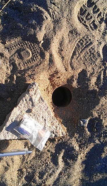
I did some other WD hides, which were also good, but there were also some excellent WD-inspired hides. I won't list the GC numbers, since I have spoiler pics, but this will give you an idea of what you are up against with these. One was a hole in the ground, covered by a rock that looked like the hundred or so other rocks in the area. Again, I looked in all of the nearby spots that are common geocache hides, before finally thinking a little differently. You really have to be confident that the damn cache is there somewhere, because otherwise you will drive yourself crazy!

There was an urban cache in the area that was also worth noting. It had been recently replaced (I was the first finder after replacement) but the set up looked very interesting. I parked next to GZ and began my search. It was a very high muggle area, with people walking by me constantly, but still a reasonable area to be searching. There really were only a few places the cache could be and after exhausting all of them... yes, we were back at the improbable again. I then noticed something that needed to be investigated and when I had a break in the muggle traffic, I touched it. Could the hide really be that bold? Yes indeed! I've seen things similar to this type of hide in San Diego, but not this well executed. The cache looked like it belonged where it was hidden, and let me correct that... it wasn't really hidden at all. It was absolutely right in plain sight. Me and the thousands of muggles passing by looked right at it. Repeatedly. Finding a cache like that is such a rush, and the creative effort to set these hides up is really inspiring. Hopefully, I can find a couple of spots to set up something this clever, because it sure beats an Altoids tin in a lamp post skirt!

Log dating back to 2001
Dawn over Palm Springs
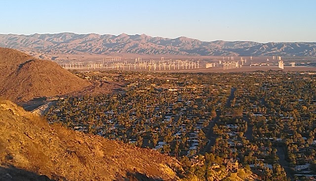
On my final morning in Palm Springs, I woke up before dawn to climb the Museum Trail up to one of the oldest caches in the area. The hike was short but steep, and a great way to wake up! The reward was an absolutely wonderful view of Palm Springs and the nearby wind farms. The sun rose as I was about half way up, and watching sunlight flood the area was very humbling. The target of the hike was 'English Tom over Palm Springs' placed by sdompier back in May, 2001 (link). A local cacher named Florian appears to be taking care of the cache, so a tip of the hat to that user as well for keeping this one alive for so long. GZ puts you in the rocks near the picnic tables, with booming views in three directions. It took a few minutes to zero in on exactly where in the rocks I was supposed to look, but once I found the right area, the cache was a quick find. I was stunned to see the original logbook in the cache!!! If you imagine the harsh conditions this cache endures every summer, the occasional heavy rains, the muggles who steal or CITO caches, it is truly amazing that the log has survived over 12 years. It is a geocaching relic! How many logs from the early days still exist in the wild? I don't know, but reading through that old log was a real treat.

Tom's plaque
The next stop was the companion cache to this classic, a puzzle cache named 'Holly Tom' placed by user Holly and Shelly in May, 2001 (link). This cache was placed by a user who had looked for the English Tom cache but didn't find it, and instead hid a new one. I like to try and solve the puzzles ahead of time, if possible, but this one appeared to be some kind of field puzzle. Near GZ, I found the answer to another question I had... who was Tom? Tom was a guy from England who loved the mountains in the area, so when he died in 1995, his family had a plaque placed here in his honor. It turned out that there wasn't much to this puzzle and the cache was a quick find. As I turned to leave, I'm pretty certain that I heard Tom telling me to join him for a few minutes as he doesn't have many visitors. So I did. Those 15 minutes were the most peaceful moments I had on this hectic trip. Stop and enjoy the views, people, that's why they place caches here!! Visiting with Tom was a great way to end my trip to Palm Springs!


Tuesday, January 21, 2014

Caching in Palm Springs: Geoart

I spent last week in Palm Springs attending a protein science conference. The meeting was very good and I had a lot of talks to hear, people to meet, and swag to grab from vendors. This left me little time for geocaching, but I managed to squeeze it in! I had scoped out the area for interesting caches, and asked some folks here in San Diego if they had some favorites. This became my to-do list. Some were on there because they were unusual hides, some were vintage, and some required some hiking. In the next few posts, I will share some of my favorites from this trip.

Beautiful moonrise
Easter Egg geoart
Last November, I did the Putting Kat on the Map series (here's the link), which was one of San Diego's first examples of geoart. I noticed that there was some nice geoart series in Palm Springs, so these became high on the to-do list. The problem with these power trails is that they can take a fair amount of time, and between meetings, breakout sessions, poster sessions, and receptions, it was hard to find a large chunk of time for power trails. I decided to try a smaller trail first, the Easter Egg Hunt series placed in March 2010 by olsenr. I skipped the second half of one of the afternoon sessions and had a couple of hours before dark. As is often the case, I stopped for a couple of other caches first (one was a Wheeler Dealer cache, more on those in a future post) so by the time I got out to Desert Hot Springs, it was getting pretty late. I had two choices: go for it and get it done before nightfall, or go back to the hotel and be a weenie. The nearly full moon was rising over the mountains, so I figured I might get a little extra light from that if I didn't quite make it. Besides, I'm no weenie. I did do some quick math and decided the best way to finish was to move quickly. Yup, I was going to run around the power trail. I was wearing hiking boots, but I had run in them before and I knew my trusty Ahnu boots were fine. So, I started at Is it Butter (link) and ran counterclockwise around the egg. Fortunately, the hides were pretty straightforward, and once I knew what to look for, many of them were instant finds. The entire loop (a dozen caches) was almost two miles and I got it done (in fading twilight) in just under 45 minutes. Great fun, and a good tune up for the next geoart series: Heartburn!

Heart-stopping views of a wind farm against the mountains
Later in the week, I had a morning free, so I decided that was when I was going to go for the heart. The Heartburn series was placed in January, 2009 by KNOCK and consists of 22 caches, each a food item that causes heartburn. I started with Pickles (link) and again worked counterclockwise around the heart. I was less pressured by time with this series, but still tried to move quickly since I was using my cell phone as a GPSr and it is notoriously bad with battery usage. Again, the hides were easy to find and almost all of them were the same type, so one just follows the arrow and signs the log. Not much thought at each cache, but that's okay. We are doing this in the name of art!! Many of the caches had clues in them (letters and numbers), which were part of a series of bonus Heartburn mystery caches. These have been archived now because some of the clues have been lost over the years and it is hard to solve the puzzle. I wrote these down anyhow, and tried to guess what the missing numbers were, based on the numbers I had, previous logs in the puzzle caches, and some logic. I got somewhat reasonable numbers for a couple of them but I wasn't confident in the numbers, or in the odds of the caches still being there. Near the bottom of the heart (Chocolate Chip Cookies and Got Milk), I ran into a huge debris field of trash. Unfortunately, trash scattered through the desert was a common theme during my caching in Palm Springs, but it was especially bad here. Glass, mattresses, TVs, car parts, construction waste, unidentified electronics, paint cans, carpeting, clothes... you name it, it was probably out here. I had to pay pretty close attention to where I was walking so as not to step on a nail or something.

Heart Shaped geoart in the desert
Anyhow, the whole group involved about a three mile hike through the desert and between the rising morning sun and the howling winds, I left the area thirsty and wind-burned. I brought a liter of water and it was gone by about cache 15. As I returned to the car, I was happy to have added a heart to my Easter egg. Two nice examples of geoart in the desert that do much more than just boost the smiley totals! A big thanks to KNOCK and olsenr for setting them up, and to the various cachers since then who have helped to maintain them.


Saturday, January 18, 2014

Caching in Palm Springs: Wrecks in the Desert

Welcome to Palm Springs
I spent last week in Palm Springs attending a protein science conference. The meeting was very good and I had a lot of talks to hear, people to meet, and swag to grab from vendors. This left me little time for geocaching, but I managed to squeeze it in! I had scoped out the area for interesting caches, and asked some folks here in San Diego if they had some favorites. This became my to-do list. Some were on there because they were unusual hides, some were vintage, and some required some hiking. In the next few posts, I will share some of my favorites from this trip.

Sand dunes near Sweetboy's Sandbox cache
There was an Earthcache near the junction of Highway 111 and I-10 that I wanted to get, so I set out during an extended lunch break to grab that cache.  As I was looking at other nearby caches, I noticed that several of them had not been found in a couple of years. In fact, they only had a couple of finds since they were first hidden in 2009. One of them (Shades 2: Sweetboy's Sandbox by SHot70 link), looked like it was in an interesting location and doable as part of my trek to the EC. I have a real soft spot for lonely caches, so this became my first stop on the way to the EC. I drove out of Palm Springs and turned off of Highway 111 onto Tipton Road, parking near the train tracks. Behind me were steep mountains and in front of me was a large wind farm. Other than that, there was a whole lotta nothing out here. I hiked parallel to the train tracks and then crossed underneath the 111 in a dry creek bed. After that was about half a mile of sand. Up the dunes, down the dunes, around the dunes but finally I came to an old lake bed (well, more of a pond really) and saw my likely target for GZ. The question was, which one? Just across the dry pond were the skeletal remains of several vehicles. In the lake bed itself were scattered car parts, beer bottles, and deteriorating tires. It looked like this had really been a great party area at one time!

The cache is in there... somewhere
GZ led me to the remains of an old van (Chevy, maybe?) and I began my search. I've done car hides before, so I looked in the usual spots but was coming up empty. I resorted to the hint (don't judge me, people!) but misinterpreted the clue and focused on one part of the car for about 15 min. I was talking to myself out there (the desert does things to you, you know), trying to work through another way to think about the hint. Fortunately, myself had another idea and I returned to a spot I had already searched, but searched it much more aggressively. Bingo! A very well-hidden mint tin, attached with a magnet. The tin was filled with sand, but I was thrilled to be the 4th to find, particularly since the last person to sign the log found it on January 29, 2012, almost exactly two years ago! This was a little surprising since it wasn't too hard to get out to this cool area, and the search itself was also pretty fun. An interesting hike, a tough search, a perfect hint, and a fun find. This was definitely one of my favorites on this trip!


Sunday, January 5, 2014

Night Caching in SoCal: Bears vs. Zombies

One of the very first caches my family ever tried was a night cache in North Carolina called 'Lost in the Dark', by rldill (link). It was a lot of fun, but unfortunately, we DNF'd it because we still really didn't know what we were doing at that point. Since that time, I have come to find that night caches are really pretty rare. Recently, I had the great fortune to do TWO night caches.

The first one was near Big Bear Lake. We had spent the night for a day or two of skiing, but the conditions were too warm and one of my daughters was sick, so we decided to leave early. As I often do, I had a list of caches that I wanted to get on this trip and one of them was the night cache 'A Night Smiley for Big Bear' by Mama Bear and 2 Cubs (link). I talked my wife into coming with me, although she's not a big cacher, but I really wanted a spotter since I would be hiking at night in an unfamiliar place (safety first, people!). GZ puts you at a trailhead near one of the ski resorts and the idea is to use a flashlight to follow a series of fire tacks.

Although it was warm, there was still snow on the trails, and the path was very icy. In the darkness, the drop offs on the right hand side of the trail seemed much more dangerous than they probably were. The trail ventured uphill and downhill, and every slip on the ice was like we were going to fall off Everest! We missed the final marker, so we went quite awhile without seeing anything before turning back and regrouping. Then we heard something in the bushes. That was about it for my wife, and since she had the flashlight, I had to plead with her to give me a few more minutes. We found the last known tack and she said she saw something strange nailed to a tree. It wasn't the cache, so I ignored it. Then she shined the light on something that looked suspicious, but she couldn't find it again by the time I got over there. I still couldn't find the final marker, and since the rustling was getting louder, we (she) decided to bail. After we got back to the cabin, I pulled up the cache listing and looked at some additional information. "Hey, that's what I saw on the tree!" she said. D'oh!! So, the next morning, I returned to where we were and the suspicious item I saw briefly in her light turned out to be the cache! It was really cool to return here in the daylight and see how things looked. Trail wasn't so bad, drop offs weren't so steep, and no wild animals near GZ. This was exactly what it was designed to be, a slightly scary but very cool adventure. Caching is SO much more interesting at night!


The hidden Zombie Meter
The TOTT in action!
Two nights ago, I teamed up with local San Diego legend BlondHiLites, a couple of new cachers, sjjjhall(s), plus my wife and daughter to find a very special night cache in La Jolla. The DAK Girls, also local legends for the truly fantastic hides they create (the Wizard's Chess series, the Indiana Jones series, etc) had a new cache publish this week. 'Night of the Zombie Apocalypse' (link) is a multicache on the UCSD campus that can only be done at night. A couple of groups found it when it first published, but it was still new enough that we didn't know what to expect. We met near GZ to find the most critical component for our search: The Zombie Meter. This device was, without question, the best TOTT I have ever used to find a cache! We boldly followed the directions on the screen, dodging zombies as they approached and making u-turns when the device mocked our poor directional choices. The goal was to find the secret zombie headquarters, and two places of zombie worship. These had to be found quickly, or else the zombies would get you and you had to return to the last found waypoint. What pressure! Our brave little group battled the zombies and found the waypoints without too much trouble. Well, that's not true. Right in the middle of our zombie apocalypse, I had to go pee, so I broke one of the cardinal rules of horror movies... never leave your group to have sex or go pee. You will surely get killed. I managed to survive and we eventually got the final coordinates. The cache description had this cute narrative about the zombies jamming the GPS signal and as we closed in on the final, we found that part was true, too! The campus buildings made our GPSr go wonky and we wandered around trying to get a good read on GZ. There was one spot I kept returning to, and while the others searched on, my family thoroughly searched this area. Finally, I found the cache! We were the third group to find it, and it was my 1500th find. After hearing all the hype about DAK Girls caches, it was nice to see they lived up to the hype! It was really awesome! Both of these night caches were definitely among the most enjoyable I have done, and offered a very unique caching experience.


Tuesday, December 24, 2013

Kumeyaay Solstice Cache

Waiting for the sun to rise
Last Saturday, I returned to another one of my favorite caches, the Kumeyaay Solstice Cache (link). It is one of San Diego's classic caches, placed in 2002 by Team Gecko. As is often the case with geocaches, it was placed to draw attention to a fantastic event that happens here every year on the winter solstice. On that day (plus or minus a day or two), the sun rises over some hills in the distance and appears to be briefly split in half.  A very cool phenomenon that the Kumeyaay indians used as part of a solar calendar. In fact, a set of circular stones was found near here years ago and the site was designated as the Cowles Mountain Observatory.

Winter solstice sunrise
Anyhow, the event happens at about 6:54 am every winter solstice, so in order to see it, you must be at that spot.  This means a pre-dawn hike half way up Cowles Mountain. I've done this a couple of years now, dragging various family members along, and have yet to get a good view of the split sun. Winter in San Diego is often associated with low clouds at dawn, or rain, and it can be quite challenging to get good weather. Saturday's weather was pretty good, so we drove out to the Staging Area at Cowles Mountain at about 5:30 am. We hit the trail at 6, and it took a good 20-30 minutes to get to the right spot. Surprisingly, there were also dozens of other people climbing the trail. I would estimate that 100-200 people were there, from infants to elderly. It was a festive atmosphere as we waited for the sun to peak over the peaks, with laughter and chatter breaking out frequently. As we reached the final minutes, though, it got quiet. Clouds hugged the distant peaks and the sun made it look like the hills were on fire. There was a narrow gap between the distant hills and the increasing cloud cover, and when the sun peaked over the hills, we had a spectacular view. The picture above shows a slight split as the light from the sun illuminates the knob-like feature that creates this effect. This shot is probably 5 seconds after the first appearance of the sun, so the most impressive split would have already happened. (Yes, the sun split phenomenon lasts all of about 4 seconds!) Unfortunately, the cloud cover near the peak obscured the best part of this show. Still, it was awesome and the crowd responded with some sporadic clapping.

Heading back to the trail head under a gorgeous sunrise.
We stayed a few minutes, talked to some geocachers who were also up there, and then began the trek back to the trailhead. If it weren't for the Solstice Cache, I might not know about this special event and I plan on keeping up this emerging holiday tradition. The cache page has a number of viewing tips (remember to NEVER look directly at the sun!) and some great pictures of how the split sun can look under ideal conditions. New pictures are posted each year, and it turned out that Sunday and Monday morning were perfect this year. Even without the perfect split, watching the sun rise on the solstice, at an ancient observatory no less, is incredibly exciting. It may not be Stonehenge, but San Diego's version is still pretty awe-inspiring!

Monday, December 16, 2013

Caching on Catalina: Part 3

Heart of Catalina
The last day of our epic hike across the Trans Catalina Trail was also going to be the longest. After two days of 5-7 mile hikes up and down relatively steep hills, we were all feeling a little sore, so the prospect of an 11 mile hike through the heart of Catalina was a bit daunting.  We left the Black Jack campground under overcast skies and made our way towards the central part of the island.  This is clearly a place few people go and it was truly spectacular through here. The isolation also meant there were no caches to be found for much of the hike.  Since this is such a wonderful segment, I decided to hide a cache myself.  Between mile 12 and 11, as we paused for a drink after a steep downgrade, I found a good spot for a hide.  I named it 'TCT: Heart of Catalina' (cache link here), to reflect the setting.  Since pack space is at a premium, and I had already used space for the replacement cache for Black Jack, this is a small container (a hanging pill bottle), but it should be pretty easy to find once you get there.  Believe me, you won't have to deal with muggles!  In fact, I will be excited to see when it get its first find.  As of this blog post, it has already gone over 4 months without a find. I will be surprised if this cache gets more than one find a year, because you have really got to want to be out there.

First glimpse of Avalon!
Anyhow, we slogged on towards Avalon and as the sun came out in the afternoon, it turned into a grind. We were tired, dirty, hungry, and starting to look forward to the final stop (and warm showers!) at the Hermit Gulch camp. We saw a lot more bison on Day 3, which helped keep the family moving, and the terrain was quite variable, from rolling scrub, to prairie-like grasslands, and eventually, roads. Around Mile Marker 9, we passed a park near the road up to the airport, which gave us hope that civilization was getting close. Near Mile Marker 8, we got our first glimpse of Avalon! All of us were really dragging along the last 1.5 miles of ridgeline before the drop down to camp.  We passed a number of muggles through here, who had hiked up from below and looked perky and hydrated. We must have looked like death warmed over! We finally made it to the Hermit Gulch Trail, which took us off the TCT and down a very steep ravine towards the campsite. My wife and I knew this part of the hike, as we had hiked up from below a few months earlier on a vacation to the island.  We stopped briefly at a cache we had logged on that trip, and found that the trackable we had dropped there was safe and sound.  The cache itself is pretty cool.  It's called 'Hermit's Graveyard' by Dmahny88 (here's the link) and has had a half dozen visitors since it was placed back in May 2012.  The cache has really unusual camo. I won't spoil it with a picture, but believe me, you will get a kick out of it. There is another cache further down the trail (closer to camp) that gets a lot more traffic, due to its proximity to the camp.  It's called 'Hermit Gulch' by Reynoldator28 (link) and we had found this guy during our previous trip as well, so we didn't stop here.
Leaving the TCT and heading to camp


We finally arrived at the camp and were thrilled to be back in civilization.  Although the idea of hiking into town was not pleasant, the thought of steaks on the grill and cold beer was enough of an incentive to hike just a little bit further.  All told, we found six caches and placed one while hiking about 23 miles over three days.  I know there are some folks that are all about the numbers, but sometimes a couple of caches are far more satisfying than 50 LPCs.  This was one of those times. I think even the geocaching purists, who probably cringed at my pill bottle hide, would say that this is what geocaching is all about.  Finding parts of the world that you would have never seen otherwise. There are still a number of caches out here, some in places even more remote. Hopefully, I can come back someday for another trek along the TCT and grab a few more.


Monday, December 2, 2013

Caching on Catalina: Part 2

Looking back towards Little Harbor
We broke camp early to begin Day 2 of our back country hike along the Trans Catalina Trail. Sheep Chute trail started out uphill and seemed to be uphill forever! Unlike Day 1 of our hike, there were very few people along this segment.  We passed one couple, and then a group of college aged guys who we had seen on the ferry. After that, we had several miles of trail all to ourselves. After about 1.5 miles (between mile marker 19 and 20), we stopped for the first cache. This one was was called 'What a View' by Madds (here's the cache page) and was published in May 2012. It took almost 7.5 months to get a FTF (in Dec 2012) and we were second to find in August 2013.  Two finds in 15 months. That's kinda lonely.


By the time we passed mile marker 18 and 17, we were all looking forward to the big treat that came at roughly the halfway point of the hike.  We had set out in the morning so that by lunchtime, we would be at the famed Airport in the Sky.  Not so that we could catch a flight back to LA and go home (at least I hope that wasn't what my family was thinking!), but because of the airport restaurant. After a day and half of backpacking, I was dreaming of a Buffalo Burger!  The views from the airport and the restaurant were awesome, and we took a much needed break here. Did I mention how good that Buffalo Burger tasted? OMG!! The food was a little pricey but man, did it ever hit the spot.  I highly recommend a stop at the airport if you hike the TCT.  You can also take the bus from Avalon up here, or fly in on a small plane.


Lunch at the airport
Airport in the Sky
Buffalo Burger!


Soapstone quarry


My family rested in the shade while I went after the two caches that were in the area.  I DNF'd a cache called 'Team Hookey' placed by Bigbadtrucker (link), which was very disappointing since the cache was placed in 2001.  It looked like one of those 'cache in a cactus' hides, so I gave it a good look but didn't want to waste all my caching time poking around in a cactus (I hear the groans on that pun).  Despite a pair of recent DNFs, the cache has only been found 50 times in 12 years. I then moved on to a more recent hide, 'Soapstone in the Sky' by kfsbunny (link) which turned out to be a very cool cache!  I followed a side trail across from the airport down to a soapstone quarry.  It turns out the quarry was used by a native american tribe and is a very important part of Catalina history.  The cache was a fairly easy find but the area was so cool I made my family hike through this trail just to see the quarry.

I  wish all bisons were this easy to find!
The final push was a 2 mile stretch down a valley and back up to the Black Jack campground.  Unlike Day 1, the sun was out and the hike was a hard one.  We stopped several times in shady areas to rest and drink.  We saw nobody through this stretch.  Nobody at all.  However, as we approached the campground, we finally saw something we had been waiting for the entire trip.  A bison!  No, not a bison in a bush, but a real bison! Very cool sighting and it gave us the energy boost to make it to the Black Jack camp.


View near the Black Jack cache
Smells like Pine!
Black Jack was probably the best camp of the trip.  Extremely remote, only a few campsites, and nestled under the only pine trees we saw on this trip.  We had a hard time figuring out which campsite was ours, and the guys from the ferry were there without a reservation, so we chatted with them while we waited to see who (if anybody) would arrive.  One of my missions on this trip was to replace the cache called (appropriately enough) 'Black Jack' (link) by DesertExplorer. Placed in 2005, it had only been found 12 times before it went missing in 2009.  Several DNFs were reported and eventually, it was under threat of archival.  I contacted the CO when I knew we would be visiting and offered to adopt the cache, but he just wanted me to replace it for now, as neither of us live very close to Catalina.  GZ for the missing cache was on the outskirts of camp, at the end of a short ridge.  Once there, I saw the remnants of the old geopile. Pretty cool.  I hid the replacement and enjoyed the view for a few minutes before hiking back to camp and out to another nearby cache, 'Smells like Pine' (link) hidden in 2006 by skpanzer. The hide site was truly spectacular, particularly in the late afternoon sun. The trail to GZ was uphill along another ridge and brought me into a copse of pines. I was enjoying the view and the trees so much, I nearly tripped over the ammo can, which was in plain view. I was thrilled to see an original logbook with logs from the 14 previous finders as well as numerous muggles who had camped at Black Jack and stumbled across this cache. Based on the muggle logs, and some of the contents of the cache, it would appear that this is a popular place for campers to take their girlfriends. I'm not sure what merit badge they were working on, but it sure sounds like a fun one!

I made my way back to camp for dinner.  Two days down and one (long) day to go.  Day three would be the final 11 mile push to the Hermit Gulch campground near Avalon.  I was also hoping it would be the day I placed my first hide on Catalina!


Saturday, November 23, 2013

Geo-art: Putting Kat on the Map

Kat on the Map
Today I had a window of opportunity to cache in the morning, and a veteran local cacher had asked earlier this week to go on a cache quest this weekend.  So, the stars aligned and we were able to get out for what would be, for me, a new one-day record for geocaches found.  What was even more exciting was that we were going to do some geo-art.


SDPD even logged this one
I teamed up with Unknown_2_You (U2U for short) at about 6:30 am, and we drove down to an area near Otay Mesa.  Mexico was clearly visible, as we were only a few miles from the border.  I hadn't cached this far south of San Diego, so there were hundreds of unfound caches down here, but since U2U is closing in on 12,000 finds, we focused on what he still needed to do. There was a smattering of new caches in the area, but the big kahuna was a cache series known as 'See Kat on the Map' (an example is here) that was placed by Kat-Attack. There are about 40 caches in this series, mainly hidden in a residential community.  Neighborhood hides are my least favorite because you never know if the neighbor with the shotgun knows about the cache.  In fact, one of the caches we found today had been signed by the SDPD (they even left a 'the SDPD was here' sticker by the hide site), so somebody must have reported some suspicious activity.  However, it turned out that most of these were fine, but the real attraction to this series for me was the geo-art.  When you look at the series on the map, it spells out the word 'KAT'. The screen shot above shows this reasonably well.  Although this is a pretty cool example of geo-art, some of these can be very elaborate. The two series below are a couple of my favorites, but you can see others at this blog. It's hard enough placing a few caches along a trail and getting it right, I can't imagine how complicated these series are to make.  Truly Geo-art!

F-16 geoart
A jet in Idaho (Picture courtesy of
The Geocaching Librarian)
One of the first examples of geo-art:
Alien Head in Nevada (GC253ZN)


One of the best examples I've seen of this type. I
looked at it several times before realizing.
I love when the log is as tricky to find as the cache!
U2U and I did this series in segments, parking on a side street and walking to 5-6 caches before moving to the next spot.  We probably did several miles of walking on this beautiful Saturday morning.  One of the things I really liked about this series was the variety of hide types.  Many times, an experienced geocacher can walk up to an urban cache and spot it instantly.  There are a number of common types of hides in the city, and it takes a lot of creativity to think up clever ways to hide things along streets.  I found many surprises in this series.  Hide sites in tiny cracks, magnetic pouches containing logs, the standard magnetic bison container, cammo'd spice containers, peanut butter jars, and Eppendorf tubes. Although I have been caching for several years, I learned several new tricks today.  I posted pictures of the coolest cammo/caches, but they are not necessarily from the Kat series (and, hopefully, no spoilers here). It was great to have a veteran geocacher like U2U along, because he was able to figure out a couple of toughies that I feared were going to be DNFs.  Speaking of those dreaded DNFs, we did have a couple that we could not find.  One where a bunch of homeowner muggles were standing right next to the bush we needed to search, and one that appeared to be missing. But between the Kat caches and some other ones in the area, we found about 40... a new 1-day record for me.  We did miss some of the Kat caches in the 'K' segment, so we wound up spelling something that looks more like 'Cat' than 'Kat', but it still looks cool on the map. I can't imagine how long it must have taken to plan this picture, set all the interesting geocaches, create all the cache pages at GC, and then maintain them. A big "Thank You" to Kat-Attack for this fantastic new series!


Thursday, November 21, 2013

Caching on Catalina: Part 1

TCT marker near Two Harbors
In early August, my family took an epic, back country hiking trip along the Trans-Catalina Trail.  The TCT is a relatively new trail that stretches across almost the entire length of Catalina Island (located about 25 miles off the coast of Los Angeles).  It was a fantastic hike, and a good multi-day adventure for our family.  Although we are not novice backpackers, (we have done some segments of the Pacific Crest Trail and we have done several grueling treks across Anza Borrego desert to Red Top), this was a long hike by our standards.  There was a very recent blog post by SoCal Hiker (here) that provides a lot of information on how to do the TCT. Information on the Catalina Island Conservancy (TCT, camping, and boating information) can be found here.

Hiking along the ridge towards Little Harbor
Little Harbor: Our camp site was on the left edge of this picture
We took the ferry from San Pedro, and after a stop at Avalon (where most people got off) the ferry took us to Two Harbors.  Our plan was to hike from Two Harbors back to Avalon and catch the return ferry there.  We picked up our permits and purchased firewood in Two Harbors, and then stopped at the general store for a few last minute items.  Our hike began around mile 26 (if you want to follow along, here is a pdf map of the trail) and not too far out of Two Harbors was a cache known as 'With Child' (link).  Unfortunately, we would have had to backtrack a bit to get to the cache, so although I was only a couple of hundred feet from GZ, we had to let it go.  We passed two more caches on the first segment, as they were again located on trails that were out of the way for us. Finally, we worked our way down the ridgeline to the place we had been longing for all day.  My family will say it was the campground, but for me it was my first cache of the trip.  We dropped our gear off at Campsite 9, and my family wanted to relax awhile before setting up camp.  I wandered off to get the cache 'Out on a limb' (link). First published by Doxyluvr in September 2011, this cache had only been found 12 times before I came along.  A typical San Diego cache would get 12 logs in the first few days after it published, so this one is kinda lonely.  I had to walk through another campsite to get to GZ, so I was glad those people were not there yet. After a brief spin around the object at GZ, I made the find.

A couple of trackables at camp
After setting up camp, taking some travel bug pics, and eating dinner, we explored the harbor.  We followed the beach to its northern end to look for a cache called 'Marley's cache' (link).  I was barefoot at the time and when I got to GZ, I realized I would have to go back to camp for shoes.  There were a lot of coordinate issues with this one when it first published, and I wasn't sure how far off the beach I was going to have to tread. Cactus thorns and long hikes do not mix well. Fortunately, the cache was a quick find, even though it was very well-cammo'd and the coords were off a bit. I was 6th to find since Sept 2011 (Doxyluvr hid this one, too).
A wonderful evening at camp
The last cache near the camp was 'SOS Rock' (link) and with a 3-star difficulty and terrain rating, I was a little hesitant to go after it.  The approach from Marley's cache looked difficult and previous logs suggested it may be quite treacherous (the owner, BMKSS, even put a 'dangerous cliffs' icon on the description).  I was tired and could not afford an unnecessary injury, so I let that one go. Besides, it gives me an excuse to come back to this wonderful little campground!  By dusk, I was the only one awake, so I took a glass of wine back to the beach. I can post pictures, but it really doesn't capture the peaceful nature of this spot. Particularly at heavy dusk, when the purples come out in the sky and the who-whish of the waves is the only stimulus.  This is why I like to geocache in these crazy places, to see things that few people ever get a chance to enjoy.


Monday, November 11, 2013

A FTF and a 4X Saturday

A sucky picture of city lights near GZ.  The moon is to the left.
A couple of new caches popped up on a Friday night, and with some free time on my hands, I decided to go after one of them. Since I reveal the cache container in this post, I will not provide a link to the cache.  It's better if you experience it yourself.  The cache was in a well known part of Mission Trails Regional Park, so I knew right away where I had to park and that the hike to the hide site would be safe to do at night.  I love hiking MTRP at night.  It's a little bit scary because it is very dark and there are TONS of coyote and who knows what else out there.  This one was less than a half mile from the trail head and even with a dying flashlight, I was able to make it to GZ without incident.  However, GZ was not exactly what I expected.  No bush, no boulder formation, no sign, no obvious hide site.  I tried re-zeroing but it was leading me to places I knew were no good for cache hides.  This hide was from an experienced geocacher, surely he would not just throw a container in a patch of weeds and call it a cache site.  The cache type was not chosen, so I wondered if it was a fake rock or some other type of trickery.  With limited light, it was hard to distinguish real from fake.  Maybe the coordinates were off.  Way off.  It had happened before on FTF hunts.  A GZ off by 30' is a LOT of ground to search at night.  And I didn't have all night.
Very, very sneaky...
Yes, there was an element of panic now.  I had come all the way out here, I was not about to leave empty handed.  Deep breaths, deep breaths. Was there any other information in the description that might help.  Anything at all.  Wait... what was that?  Ahhh.... bingo!  That was the feeling that I craved on these FTF hunts.  One of the better cache containers I have seen in awhile, and hidden in such a natural state. Very satisfying.  I love these kinds of hides!!

Mission Bay: Enchanted Isle in the foreground and
Sea World in the distance (the sky tower)
Saturday was a day for Munzee.  With normal 'green' munzees worth 4X the normal points (20 points for a cap or deploy), it was time to crank up the score.  Thankfully, Jayterho had recently deployed a bunch of new munzees along the bayfront in Mission Bay, so I had a great place to go cap green munzees.  I capped about 10 or so in the morning, during a walk with my wife and geopets, but we had to leave because of another obligation.  So I came back in the afternoon to finish them off.  Capped a few nearby Motel munzees and was able to get a room in both, which means I get residual points when other people cap them even though I didn't deploy the munzee. I followed the sidewalk from Tecolote Shores park, past the Hilton, and ended near Mission Bay park.  As I was finishing, I ran into ThunderousVoice, one of the local legends in both geocaching and munzee.  He's been laid up for a few weeks, but hobbled out for the same series I was doing.  We chatted for a bit and when I reached the end of Jayterho's trail, I was at the parking lot where ThunderousVoice had parked, so I deployed three new ones for him to cap after he got back to the car.  He was first to cap on all three! I ended up scoring over 600 points and moved up to Level 57.  Our clan earned the first weapon and made good progress towards the Mace (most of us are over 500 points now).  If you remember my last Clan post (here), I did pretty well with strategy #1 and #2.  More importantly, I got to spend several hours in a beautiful part of San Diego!