Tuesday, December 24, 2013

Kumeyaay Solstice Cache

Waiting for the sun to rise
Last Saturday, I returned to another one of my favorite caches, the Kumeyaay Solstice Cache (link). It is one of San Diego's classic caches, placed in 2002 by Team Gecko. As is often the case with geocaches, it was placed to draw attention to a fantastic event that happens here every year on the winter solstice. On that day (plus or minus a day or two), the sun rises over some hills in the distance and appears to be briefly split in half.  A very cool phenomenon that the Kumeyaay indians used as part of a solar calendar. In fact, a set of circular stones was found near here years ago and the site was designated as the Cowles Mountain Observatory.

Winter solstice sunrise
Anyhow, the event happens at about 6:54 am every winter solstice, so in order to see it, you must be at that spot.  This means a pre-dawn hike half way up Cowles Mountain. I've done this a couple of years now, dragging various family members along, and have yet to get a good view of the split sun. Winter in San Diego is often associated with low clouds at dawn, or rain, and it can be quite challenging to get good weather. Saturday's weather was pretty good, so we drove out to the Staging Area at Cowles Mountain at about 5:30 am. We hit the trail at 6, and it took a good 20-30 minutes to get to the right spot. Surprisingly, there were also dozens of other people climbing the trail. I would estimate that 100-200 people were there, from infants to elderly. It was a festive atmosphere as we waited for the sun to peak over the peaks, with laughter and chatter breaking out frequently. As we reached the final minutes, though, it got quiet. Clouds hugged the distant peaks and the sun made it look like the hills were on fire. There was a narrow gap between the distant hills and the increasing cloud cover, and when the sun peaked over the hills, we had a spectacular view. The picture above shows a slight split as the light from the sun illuminates the knob-like feature that creates this effect. This shot is probably 5 seconds after the first appearance of the sun, so the most impressive split would have already happened. (Yes, the sun split phenomenon lasts all of about 4 seconds!) Unfortunately, the cloud cover near the peak obscured the best part of this show. Still, it was awesome and the crowd responded with some sporadic clapping.

Heading back to the trail head under a gorgeous sunrise.
We stayed a few minutes, talked to some geocachers who were also up there, and then began the trek back to the trailhead. If it weren't for the Solstice Cache, I might not know about this special event and I plan on keeping up this emerging holiday tradition. The cache page has a number of viewing tips (remember to NEVER look directly at the sun!) and some great pictures of how the split sun can look under ideal conditions. New pictures are posted each year, and it turned out that Sunday and Monday morning were perfect this year. Even without the perfect split, watching the sun rise on the solstice, at an ancient observatory no less, is incredibly exciting. It may not be Stonehenge, but San Diego's version is still pretty awe-inspiring!

Thursday, December 19, 2013

Christmas Card Lane Flash Mob

One of my personal favorites...
Last night I attended the 3rd annual Christmas Card Lane flash mob event (link) hosted by Silver Horde.  The cache 'Christmas Card Lane Cache' is also on the premises (link) and is one of the few caches that is only available to log during December. I've attended this event every year and this year was as good as ever.  Christmas Card Lane only exists one month out of the year, when a typical suburban neighborhood is transformed into a colorful spectacle of lights.  Each house in the approximately two block area has a theme, and creates a Christmas Card-like display.  I think it is so cool that the neighbor participation rate is so high, probably more than 90%.  It makes the area really a magical place and people come from all over San Diego to see it.  The place is just packed with people and cars! The flash mob event started three years ago and it was one of my first events as a geocacher.  I didn't know many people back then, but it was a fun (and quick) event, plus the walk around the neighborhood was very cool.  So, we have made this a yearly tradition.  Last year, we brought our new puppy with us and he broke free from his collar and raced across Black Mountain road.  Cars were zipping by at 50+ mph as he chased away from our frantic efforts to catch him on the side of the road.  A terrifying moment that still gives me the shivers, but we finally caught him unharmed. A Christmas miracle! He made his return this year and has a trackable collar now, so both of our dogs could be discovered.
Disney themes were common

Anyhow, it was fun chatting with some old friends and meeting some new ones. ClanCambellChandler, SDGEOMOM74 and I talked about Munzee (in hushed tones, of course). FlagMan and Deniel3 were also there, so we caught up a bit.  Said hello to LLOT, Trixxster, and of course, the gracious host, Silver Horde. Lulu499 was the winner of the FTF raffle (yea Lulu!). The event meal was larger this year, including both candy canes AND chocolate kisses. Mmmm. As the event was winding down, we did a group picture (below) and then were serenaded by a group of young carolers.  If this doesn't get you in the mood for the holidays, you should probably have your pulse checked!  I grabbed a couple of trackables from the table and I was off to see the neighborhood.

Harry Potter
My family arrived right after the event, so I arranged to meet them at the site of a new cache 'Day 18 - Christmas light car tour in PJs' (link).  This is part of the geo-advent calendar series that FlagMan is putting out this year.  One cache gets published per day.  Like the 12 Redneck Days of Christmas series (a hysterical series put together by Habu! two years ago), it will probably take me years to finish them all, but no matter, it's all good. I found the cache quickly, but I waited out several waves of muggles who wanted to pet the geopets before I was able to sign and replace the log.  By that point, my family had arrived and it was time to put the GPSr away and enjoy the lights.  Let me know about your favorite Christmas-themed caches in the comments below!


Flash mob group shot
(photo courtesy of Trixxster, with permission)

Monday, December 16, 2013

Caching on Catalina: Part 3

Heart of Catalina
The last day of our epic hike across the Trans Catalina Trail was also going to be the longest. After two days of 5-7 mile hikes up and down relatively steep hills, we were all feeling a little sore, so the prospect of an 11 mile hike through the heart of Catalina was a bit daunting.  We left the Black Jack campground under overcast skies and made our way towards the central part of the island.  This is clearly a place few people go and it was truly spectacular through here. The isolation also meant there were no caches to be found for much of the hike.  Since this is such a wonderful segment, I decided to hide a cache myself.  Between mile 12 and 11, as we paused for a drink after a steep downgrade, I found a good spot for a hide.  I named it 'TCT: Heart of Catalina' (cache link here), to reflect the setting.  Since pack space is at a premium, and I had already used space for the replacement cache for Black Jack, this is a small container (a hanging pill bottle), but it should be pretty easy to find once you get there.  Believe me, you won't have to deal with muggles!  In fact, I will be excited to see when it get its first find.  As of this blog post, it has already gone over 4 months without a find. I will be surprised if this cache gets more than one find a year, because you have really got to want to be out there.

First glimpse of Avalon!
Anyhow, we slogged on towards Avalon and as the sun came out in the afternoon, it turned into a grind. We were tired, dirty, hungry, and starting to look forward to the final stop (and warm showers!) at the Hermit Gulch camp. We saw a lot more bison on Day 3, which helped keep the family moving, and the terrain was quite variable, from rolling scrub, to prairie-like grasslands, and eventually, roads. Around Mile Marker 9, we passed a park near the road up to the airport, which gave us hope that civilization was getting close. Near Mile Marker 8, we got our first glimpse of Avalon! All of us were really dragging along the last 1.5 miles of ridgeline before the drop down to camp.  We passed a number of muggles through here, who had hiked up from below and looked perky and hydrated. We must have looked like death warmed over! We finally made it to the Hermit Gulch Trail, which took us off the TCT and down a very steep ravine towards the campsite. My wife and I knew this part of the hike, as we had hiked up from below a few months earlier on a vacation to the island.  We stopped briefly at a cache we had logged on that trip, and found that the trackable we had dropped there was safe and sound.  The cache itself is pretty cool.  It's called 'Hermit's Graveyard' by Dmahny88 (here's the link) and has had a half dozen visitors since it was placed back in May 2012.  The cache has really unusual camo. I won't spoil it with a picture, but believe me, you will get a kick out of it. There is another cache further down the trail (closer to camp) that gets a lot more traffic, due to its proximity to the camp.  It's called 'Hermit Gulch' by Reynoldator28 (link) and we had found this guy during our previous trip as well, so we didn't stop here.
Leaving the TCT and heading to camp


We finally arrived at the camp and were thrilled to be back in civilization.  Although the idea of hiking into town was not pleasant, the thought of steaks on the grill and cold beer was enough of an incentive to hike just a little bit further.  All told, we found six caches and placed one while hiking about 23 miles over three days.  I know there are some folks that are all about the numbers, but sometimes a couple of caches are far more satisfying than 50 LPCs.  This was one of those times. I think even the geocaching purists, who probably cringed at my pill bottle hide, would say that this is what geocaching is all about.  Finding parts of the world that you would have never seen otherwise. There are still a number of caches out here, some in places even more remote. Hopefully, I can come back someday for another trek along the TCT and grab a few more.


Sunday, December 8, 2013

12 Days of Munzee Christmas

So, our clan finished in 118th place in Clan Battle 8.  We earned one weapon and finished in the middle of the pack.  I hit my 1,000 point goal, but we had a couple of stragglers last month, so we didn't get the scoring we needed from everybody.  However, Clan Battle 9 is even worse.  A last minute cancellation left us with only 9 players, so we won't qualify for anything this month.  Very unfortunate, as Munzee has Christmas themed weapons this month, which would have been cool.

XmasCover
However, all is not lost! Munzee is running a very cool promotion for Christmas, which you can read about here. In a nutshell (or chestnut, since this is the holiday season, after all), icons will start appearing on the map December 13th. 20 points for the capture and 10 points to the owner of the host munzee. Every day thereafter, new icons will appear on the map.  Random places, random times, and if you manage to capture 6 of the 12, there will be a special badge in your Christmas stocking this year! I'm going to try and get all 12... even the goofy Christmas pickle that is supposed to appear on the 16th.  I am a bit disappointed that there wasn't a cool icon for the Solstice on the 21st, but I am hoping to have a geocaching related event for that special date!

Not too excited about collecting icons? That's okay, Munzee has upped the ante. During Dec 13-24, every capture and deploy makes you eligible for some cool prizes! Battery packs, GPS units, mysteries, motels, virtuals (maybe even the new mystery virtual!), and socials.  On the 24th, capping or deploying activity qualifies you for a chance to win a premium membership! As a premium member myself, that is a great prize! So, even though our Clan got screwed up this month, I'll be out there growing the map.  Let me know if you cap some of the icons or if you win any of these cool prizes!

Monday, December 2, 2013

Caching on Catalina: Part 2

Looking back towards Little Harbor
We broke camp early to begin Day 2 of our back country hike along the Trans Catalina Trail. Sheep Chute trail started out uphill and seemed to be uphill forever! Unlike Day 1 of our hike, there were very few people along this segment.  We passed one couple, and then a group of college aged guys who we had seen on the ferry. After that, we had several miles of trail all to ourselves. After about 1.5 miles (between mile marker 19 and 20), we stopped for the first cache. This one was was called 'What a View' by Madds (here's the cache page) and was published in May 2012. It took almost 7.5 months to get a FTF (in Dec 2012) and we were second to find in August 2013.  Two finds in 15 months. That's kinda lonely.


By the time we passed mile marker 18 and 17, we were all looking forward to the big treat that came at roughly the halfway point of the hike.  We had set out in the morning so that by lunchtime, we would be at the famed Airport in the Sky.  Not so that we could catch a flight back to LA and go home (at least I hope that wasn't what my family was thinking!), but because of the airport restaurant. After a day and half of backpacking, I was dreaming of a Buffalo Burger!  The views from the airport and the restaurant were awesome, and we took a much needed break here. Did I mention how good that Buffalo Burger tasted? OMG!! The food was a little pricey but man, did it ever hit the spot.  I highly recommend a stop at the airport if you hike the TCT.  You can also take the bus from Avalon up here, or fly in on a small plane.


Lunch at the airport
Airport in the Sky
Buffalo Burger!


Soapstone quarry


My family rested in the shade while I went after the two caches that were in the area.  I DNF'd a cache called 'Team Hookey' placed by Bigbadtrucker (link), which was very disappointing since the cache was placed in 2001.  It looked like one of those 'cache in a cactus' hides, so I gave it a good look but didn't want to waste all my caching time poking around in a cactus (I hear the groans on that pun).  Despite a pair of recent DNFs, the cache has only been found 50 times in 12 years. I then moved on to a more recent hide, 'Soapstone in the Sky' by kfsbunny (link) which turned out to be a very cool cache!  I followed a side trail across from the airport down to a soapstone quarry.  It turns out the quarry was used by a native american tribe and is a very important part of Catalina history.  The cache was a fairly easy find but the area was so cool I made my family hike through this trail just to see the quarry.

I  wish all bisons were this easy to find!
The final push was a 2 mile stretch down a valley and back up to the Black Jack campground.  Unlike Day 1, the sun was out and the hike was a hard one.  We stopped several times in shady areas to rest and drink.  We saw nobody through this stretch.  Nobody at all.  However, as we approached the campground, we finally saw something we had been waiting for the entire trip.  A bison!  No, not a bison in a bush, but a real bison! Very cool sighting and it gave us the energy boost to make it to the Black Jack camp.


View near the Black Jack cache
Smells like Pine!
Black Jack was probably the best camp of the trip.  Extremely remote, only a few campsites, and nestled under the only pine trees we saw on this trip.  We had a hard time figuring out which campsite was ours, and the guys from the ferry were there without a reservation, so we chatted with them while we waited to see who (if anybody) would arrive.  One of my missions on this trip was to replace the cache called (appropriately enough) 'Black Jack' (link) by DesertExplorer. Placed in 2005, it had only been found 12 times before it went missing in 2009.  Several DNFs were reported and eventually, it was under threat of archival.  I contacted the CO when I knew we would be visiting and offered to adopt the cache, but he just wanted me to replace it for now, as neither of us live very close to Catalina.  GZ for the missing cache was on the outskirts of camp, at the end of a short ridge.  Once there, I saw the remnants of the old geopile. Pretty cool.  I hid the replacement and enjoyed the view for a few minutes before hiking back to camp and out to another nearby cache, 'Smells like Pine' (link) hidden in 2006 by skpanzer. The hide site was truly spectacular, particularly in the late afternoon sun. The trail to GZ was uphill along another ridge and brought me into a copse of pines. I was enjoying the view and the trees so much, I nearly tripped over the ammo can, which was in plain view. I was thrilled to see an original logbook with logs from the 14 previous finders as well as numerous muggles who had camped at Black Jack and stumbled across this cache. Based on the muggle logs, and some of the contents of the cache, it would appear that this is a popular place for campers to take their girlfriends. I'm not sure what merit badge they were working on, but it sure sounds like a fun one!

I made my way back to camp for dinner.  Two days down and one (long) day to go.  Day three would be the final 11 mile push to the Hermit Gulch campground near Avalon.  I was also hoping it would be the day I placed my first hide on Catalina!


Saturday, November 23, 2013

Geo-art: Putting Kat on the Map

Kat on the Map
Today I had a window of opportunity to cache in the morning, and a veteran local cacher had asked earlier this week to go on a cache quest this weekend.  So, the stars aligned and we were able to get out for what would be, for me, a new one-day record for geocaches found.  What was even more exciting was that we were going to do some geo-art.


SDPD even logged this one
I teamed up with Unknown_2_You (U2U for short) at about 6:30 am, and we drove down to an area near Otay Mesa.  Mexico was clearly visible, as we were only a few miles from the border.  I hadn't cached this far south of San Diego, so there were hundreds of unfound caches down here, but since U2U is closing in on 12,000 finds, we focused on what he still needed to do. There was a smattering of new caches in the area, but the big kahuna was a cache series known as 'See Kat on the Map' (an example is here) that was placed by Kat-Attack. There are about 40 caches in this series, mainly hidden in a residential community.  Neighborhood hides are my least favorite because you never know if the neighbor with the shotgun knows about the cache.  In fact, one of the caches we found today had been signed by the SDPD (they even left a 'the SDPD was here' sticker by the hide site), so somebody must have reported some suspicious activity.  However, it turned out that most of these were fine, but the real attraction to this series for me was the geo-art.  When you look at the series on the map, it spells out the word 'KAT'. The screen shot above shows this reasonably well.  Although this is a pretty cool example of geo-art, some of these can be very elaborate. The two series below are a couple of my favorites, but you can see others at this blog. It's hard enough placing a few caches along a trail and getting it right, I can't imagine how complicated these series are to make.  Truly Geo-art!

F-16 geoart
A jet in Idaho (Picture courtesy of
The Geocaching Librarian)
One of the first examples of geo-art:
Alien Head in Nevada (GC253ZN)


One of the best examples I've seen of this type. I
looked at it several times before realizing.
I love when the log is as tricky to find as the cache!
U2U and I did this series in segments, parking on a side street and walking to 5-6 caches before moving to the next spot.  We probably did several miles of walking on this beautiful Saturday morning.  One of the things I really liked about this series was the variety of hide types.  Many times, an experienced geocacher can walk up to an urban cache and spot it instantly.  There are a number of common types of hides in the city, and it takes a lot of creativity to think up clever ways to hide things along streets.  I found many surprises in this series.  Hide sites in tiny cracks, magnetic pouches containing logs, the standard magnetic bison container, cammo'd spice containers, peanut butter jars, and Eppendorf tubes. Although I have been caching for several years, I learned several new tricks today.  I posted pictures of the coolest cammo/caches, but they are not necessarily from the Kat series (and, hopefully, no spoilers here). It was great to have a veteran geocacher like U2U along, because he was able to figure out a couple of toughies that I feared were going to be DNFs.  Speaking of those dreaded DNFs, we did have a couple that we could not find.  One where a bunch of homeowner muggles were standing right next to the bush we needed to search, and one that appeared to be missing. But between the Kat caches and some other ones in the area, we found about 40... a new 1-day record for me.  We did miss some of the Kat caches in the 'K' segment, so we wound up spelling something that looks more like 'Cat' than 'Kat', but it still looks cool on the map. I can't imagine how long it must have taken to plan this picture, set all the interesting geocaches, create all the cache pages at GC, and then maintain them. A big "Thank You" to Kat-Attack for this fantastic new series!


Thursday, November 21, 2013

Caching on Catalina: Part 1

TCT marker near Two Harbors
In early August, my family took an epic, back country hiking trip along the Trans-Catalina Trail.  The TCT is a relatively new trail that stretches across almost the entire length of Catalina Island (located about 25 miles off the coast of Los Angeles).  It was a fantastic hike, and a good multi-day adventure for our family.  Although we are not novice backpackers, (we have done some segments of the Pacific Crest Trail and we have done several grueling treks across Anza Borrego desert to Red Top), this was a long hike by our standards.  There was a very recent blog post by SoCal Hiker (here) that provides a lot of information on how to do the TCT. Information on the Catalina Island Conservancy (TCT, camping, and boating information) can be found here.

Hiking along the ridge towards Little Harbor
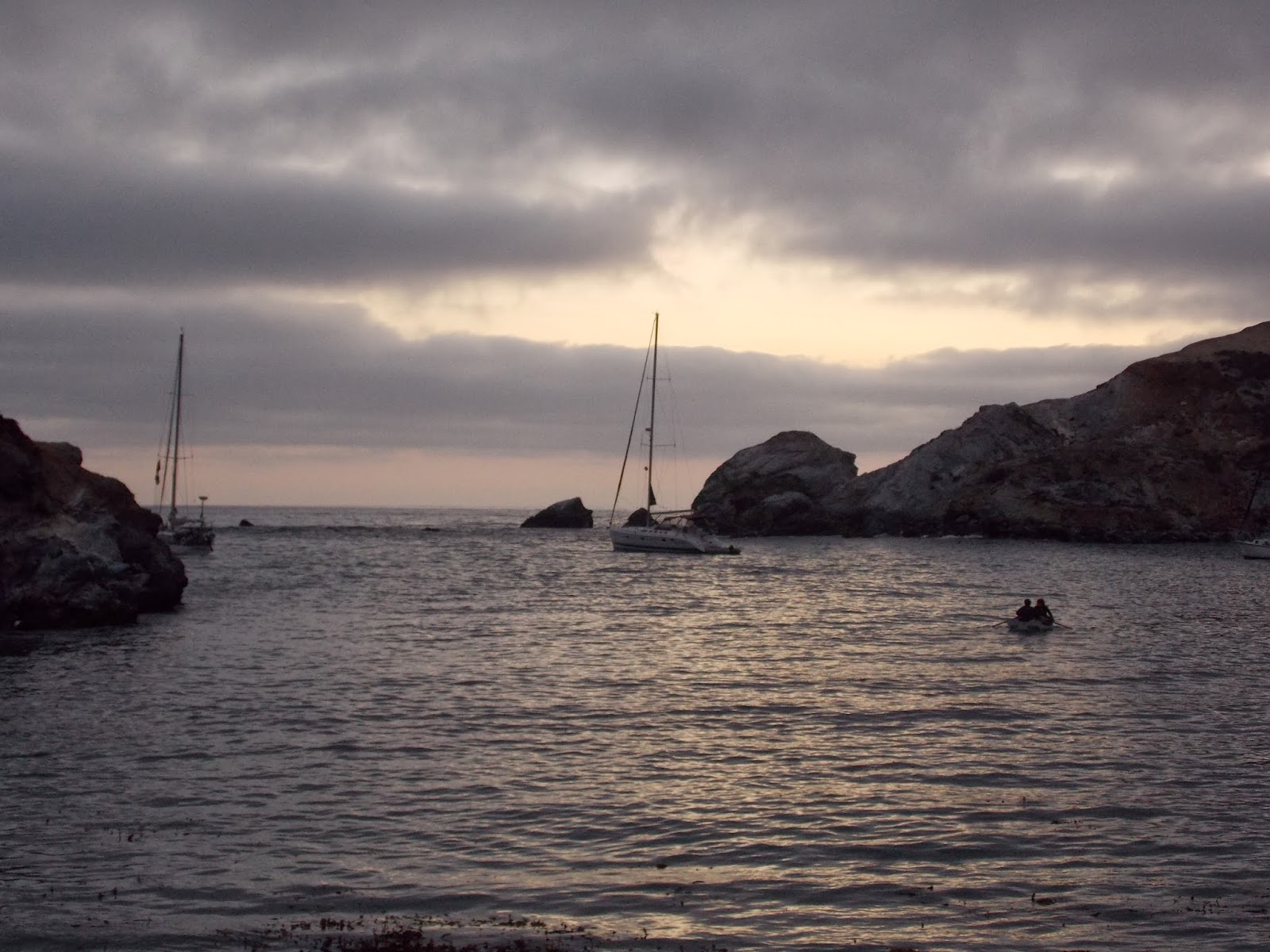
Little Harbor: Our camp site was on the left edge of this picture
We took the ferry from San Pedro, and after a stop at Avalon (where most people got off) the ferry took us to Two Harbors.  Our plan was to hike from Two Harbors back to Avalon and catch the return ferry there.  We picked up our permits and purchased firewood in Two Harbors, and then stopped at the general store for a few last minute items.  Our hike began around mile 26 (if you want to follow along, here is a pdf map of the trail) and not too far out of Two Harbors was a cache known as 'With Child' (link).  Unfortunately, we would have had to backtrack a bit to get to the cache, so although I was only a couple of hundred feet from GZ, we had to let it go.  We passed two more caches on the first segment, as they were again located on trails that were out of the way for us. Finally, we worked our way down the ridgeline to the place we had been longing for all day.  My family will say it was the campground, but for me it was my first cache of the trip.  We dropped our gear off at Campsite 9, and my family wanted to relax awhile before setting up camp.  I wandered off to get the cache 'Out on a limb' (link). First published by Doxyluvr in September 2011, this cache had only been found 12 times before I came along.  A typical San Diego cache would get 12 logs in the first few days after it published, so this one is kinda lonely.  I had to walk through another campsite to get to GZ, so I was glad those people were not there yet. After a brief spin around the object at GZ, I made the find.

A couple of trackables at camp
After setting up camp, taking some travel bug pics, and eating dinner, we explored the harbor.  We followed the beach to its northern end to look for a cache called 'Marley's cache' (link).  I was barefoot at the time and when I got to GZ, I realized I would have to go back to camp for shoes.  There were a lot of coordinate issues with this one when it first published, and I wasn't sure how far off the beach I was going to have to tread. Cactus thorns and long hikes do not mix well. Fortunately, the cache was a quick find, even though it was very well-cammo'd and the coords were off a bit. I was 6th to find since Sept 2011 (Doxyluvr hid this one, too).
A wonderful evening at camp
The last cache near the camp was 'SOS Rock' (link) and with a 3-star difficulty and terrain rating, I was a little hesitant to go after it.  The approach from Marley's cache looked difficult and previous logs suggested it may be quite treacherous (the owner, BMKSS, even put a 'dangerous cliffs' icon on the description).  I was tired and could not afford an unnecessary injury, so I let that one go. Besides, it gives me an excuse to come back to this wonderful little campground!  By dusk, I was the only one awake, so I took a glass of wine back to the beach. I can post pictures, but it really doesn't capture the peaceful nature of this spot. Particularly at heavy dusk, when the purples come out in the sky and the who-whish of the waves is the only stimulus.  This is why I like to geocache in these crazy places, to see things that few people ever get a chance to enjoy.


Monday, November 11, 2013

A FTF and a 4X Saturday

A sucky picture of city lights near GZ.  The moon is to the left.
A couple of new caches popped up on a Friday night, and with some free time on my hands, I decided to go after one of them. Since I reveal the cache container in this post, I will not provide a link to the cache.  It's better if you experience it yourself.  The cache was in a well known part of Mission Trails Regional Park, so I knew right away where I had to park and that the hike to the hide site would be safe to do at night.  I love hiking MTRP at night.  It's a little bit scary because it is very dark and there are TONS of coyote and who knows what else out there.  This one was less than a half mile from the trail head and even with a dying flashlight, I was able to make it to GZ without incident.  However, GZ was not exactly what I expected.  No bush, no boulder formation, no sign, no obvious hide site.  I tried re-zeroing but it was leading me to places I knew were no good for cache hides.  This hide was from an experienced geocacher, surely he would not just throw a container in a patch of weeds and call it a cache site.  The cache type was not chosen, so I wondered if it was a fake rock or some other type of trickery.  With limited light, it was hard to distinguish real from fake.  Maybe the coordinates were off.  Way off.  It had happened before on FTF hunts.  A GZ off by 30' is a LOT of ground to search at night.  And I didn't have all night.
Very, very sneaky...
Yes, there was an element of panic now.  I had come all the way out here, I was not about to leave empty handed.  Deep breaths, deep breaths. Was there any other information in the description that might help.  Anything at all.  Wait... what was that?  Ahhh.... bingo!  That was the feeling that I craved on these FTF hunts.  One of the better cache containers I have seen in awhile, and hidden in such a natural state. Very satisfying.  I love these kinds of hides!!

Mission Bay: Enchanted Isle in the foreground and
Sea World in the distance (the sky tower)
Saturday was a day for Munzee.  With normal 'green' munzees worth 4X the normal points (20 points for a cap or deploy), it was time to crank up the score.  Thankfully, Jayterho had recently deployed a bunch of new munzees along the bayfront in Mission Bay, so I had a great place to go cap green munzees.  I capped about 10 or so in the morning, during a walk with my wife and geopets, but we had to leave because of another obligation.  So I came back in the afternoon to finish them off.  Capped a few nearby Motel munzees and was able to get a room in both, which means I get residual points when other people cap them even though I didn't deploy the munzee. I followed the sidewalk from Tecolote Shores park, past the Hilton, and ended near Mission Bay park.  As I was finishing, I ran into ThunderousVoice, one of the local legends in both geocaching and munzee.  He's been laid up for a few weeks, but hobbled out for the same series I was doing.  We chatted for a bit and when I reached the end of Jayterho's trail, I was at the parking lot where ThunderousVoice had parked, so I deployed three new ones for him to cap after he got back to the car.  He was first to cap on all three! I ended up scoring over 600 points and moved up to Level 57.  Our clan earned the first weapon and made good progress towards the Mace (most of us are over 500 points now).  If you remember my last Clan post (here), I did pretty well with strategy #1 and #2.  More importantly, I got to spend several hours in a beautiful part of San Diego!


Thursday, November 7, 2013

Travel Bugs in Space


Event souvenir from geocaching.com
Last night, I attended the ‘Geocaching rockets into space (again)’ event in San Diego (link).  This was a special event, as we were gathered to watch a Travel Bug launch into space!  Well, it was an astronaut who was launched and he happened to be carrying a TB with him, but still… it is only the second time that geocaching has been brought to the ISS, so we were all stoked.  Attendees who logged this event also earned a special souvenir for their geocaching profile (shown on left).  You can read some of the background on the story (here). The cache on the Space Station is listed here. If you want to follow the travel bug, here is the page.

Courtyard crowd
The event was held at Acoustic Ales Brewing Experiment, which is located off Hancock Rd near the airport.  Turnout was great! I don’t have the official attendance figures, but early estimates are in the 60-70 range, which is pretty good for a weeknight event.  Particularly since there were two similar events in the greater San Diego area.  The beer here was very good. I had a sample of one of the cask beers (the name was long and had Chinook in it, so it must be good, right?) and also tried the Mosh Pit.  It was a little tamer than a real mosh pit, but was tasty. Thanks to ClanCampbellChandler for springing for my beer, I’ll buy the first round at the next event!

No TBs made it to space here
Some of us attempted to launch our own TBs into space using stomp rockets, which was a lot of fun.  Prizes were awarded for highest launch etc, but we all hoped that the real Russian rocket would fly higher (and straighter!) than our feeble efforts.  After the courtyard was littered with the debris of a thousand failed launches, it was time to eat.  Fish tacos out front (yummy), sandwiches and cupcakes inside.  The cupcakes were A-mazing!!!  Thanks to brilynn.d for bringing them and for braving the crowds to grab the last one for me! I made time to chat with Loookin4u about a possible new quest for the Red Top caches.  I’ll have some blogs about my previous adventures at Red Top soon.  Deniel3 needed some help with a puzzle cache involving DNA, so I gave him a little shove in the right direction.  LLOT and I talked about his sailing adventures.  CCC (who is also JP92071), brilynn.d, and I also talked about Munzee.  Had to keep these discussions very hushed, lest we get thrown out of the geo-party!  It was great to have so many folks I knew there last night!

Flagman in his space suit
Just after the launch
Eventually, Flagman (our wonderful host!) called the geo-crowd to order and made a few announcements.  We were hoping he was going to volunteer to go up on the next ISS mission (I mean, he’s got the snappy space suit, what else do you need?) but he was just offering up a few more prizes.  Then, with the bar silent, the volume on the TVs was raised to hear the final countdown (cue the Europe song).  It was a bit surreal.  The bar, deafening only moments earlier, was completely silent (the non geocaching patrons were surely wondering what was going on).  Moments later, there was a thunderous roar as the Soyuz rocket lifted smoothly off the launch pad.  As they approached space, a capsule shot showed them reading some kind of manual, leaving some to remark that it was a little early to be checking the hint on the ISS cache. 


Suspicious mob spotted near airport
With the TB safely on its way to the ISS, many people started heading for the exits.  We weren’t done for the night, though.  Bar hopping?  No way… about 15-20 of us went off in search of a nearby cache (GC4QMH3).  We had to walk several blocks and cross over the train tracks to get to an isolated area near the airport.  I’m sure it is cool here during the day (and probably very busy!) but aside from a few FedEx trucks and some homeless muggles, we were the only ones out last night.  Osteado made the find and Trixxster signed us all in.  Fun times, but I think the locals were really wondering what this pack of folks was doing out so late on a Wednesday night!! Just a bunch of crazy San Diego geocachers.  Unfortunately, in my excitement to seek this cache, it turned out I didn’t sign the event log… apparently the one in the bathroom was only a replacement! 
Not the event log!


Tuesday, November 5, 2013

Geo-searching in Primm, NV

Roller Coaster on Primm Blvd.
The playa at Ivanpah
On the way home from Geocoinfest, I stopped in Primm, NV.  Primm is the little town on the border of California and Nevada.  It is also home to a number of geocaches, a couple Earthcaches, and some munzees, including an elusive Campfire Munzee. I had stopped in Primm on the way to Vegas and grabbed a few caches, but Wayward Nation's Campfire Munzee was in a location that I was not comfortable going to in the dark (and that's really saying something!).  Turns out it wasn't so bad, but a solo night hike into unfamiliar desert terrain can turn into one of those "Geocacher goes missing in desert" stories.  So, daytime was much safer and a lot cooler as well since I could actually see stuff.  The Earthcache was at Ivanpah Dry Lake (here's the link) and, as most ECs are, it was very interesting.  Ivanpah is located in the Mojave desert and, obviously, is a dry lake bed or 'playa'.  For those of you who have been to Burning Man, that festival is held on a similar playa.  Ivanpah is a very dry, flat area, and the concentrated salts in the dirt limit plant growth.  These conditions and the prevailing winds make it a very popular place for land sailing.  In 2009, the world land sailing speed record was set here (126 mph).  Unfortunately, because of the government shutdown, the area was closed and I didn't get to see anybody sailing. I did get the required information for the Earthcache (again, forcing me to observe things I might not have otherwise noticed), and I finally did capture the elusive Campfire Munzee!!  

     I grabbed the nearby cache 'Just over the Fence' (link), which sits on the CA/NV border.  A nice Ammo Can that has seen a lot of use over the years.  Well-guarded by some rusty barbed wire marking the border, but nothing too dangerous.  I also dropped one of my own Travel Bugs in the Sloan Exit Travel Bug Rest Stop (link), which was a few miles before Primm, in a little town called Sloan. If you want to follow this CA-themed travel bug as starts its travels, visit the TB's page here.


File:Zzyzx road.jpg
Exit sign
(photo by Christopher Mann McKay)

Zzyzx Rd. Earthcache
Late afternoon on Zzyzx Rd. in the Mojave Desert
   Crossing the border back into California, I drove a few miles down I-15 to an empty little exit labeled Zzyzx Road (don't ask me how to pronounce it!).  I saw this on the map when planning this trip and, fortunately, there is another Earthcache here, so I had an excuse to stop and check this area out. The Earthcache was named 'Zzyzx: The Oldest Rocks in the World' (here's the link) and I have to say, this was one of the hardest ECs I have ever done.  The logging requirements involved seven questions, most relating to the geology of the area.  I was very interested to learn about the age of the rocks in the area (which were different depending on which way you looked) and how those rocks came to be in the various locations.  The oldest rocks here were pre-Cambrian gniess that were formed over 1.5 billion years ago!!  The area was just gorgeous, especially in the soft light of a late October afternoon.  After I obtained what I hoped was the right information for this cache, I continued my drive towards home.  Along the way, I noticed similar rock formations along the road and found myself trying to identify them.


Sunday, November 3, 2013

Munzee Clan Battle #8 begins!

After two days of scrambling to get the required ten players, our clan began battle last night.  This is the eighth clan battle that Munzee has done, and the third for which I have participated. My clan, the Mixed Doh Nutz, is an offshoot of the original Mixed Nutz clan started by Vanderarban.  Vanderarban recruited me to her clan in September, which was the first time that clan weapons were available.  It's an intense but fun 28 days of group Munzee.  The goal is to score as many points as possible as a group and compete against other clans around the world (about 250 different clans now).  We had munziers from all over the country, Canada, and Europe on the Mixed Nutz clan.  The weapons, which are merely special munzees that you win by hitting certain point totals, were a great new feature as they are only available via clan warfare, have special functions, and give you a unique icon when capped. To get these, every member of the clan has to hit 500 points (Mace munzee), 1000 points (Longsword munzee), or 2500 points (The Chuck).  The Chuck is a cache of 5 Maces and 5 Longswords.  We qualified for the Chuck on the last day as two people scrambled to get the final points.  It was quite exciting rooting for a stranger in Canada to find enough munzees to finally push us over the edge.

For the last two months, I have been with the Dohs.  It's a more relaxed group and that works for me because scoring 2500 points in a month is tough in San Diego.  I did it in September, but I had to drive to LA so I could go capping in a Mystery Garden.  Even with the string of virtuals I hit along Las Vegas boulevard (see post here), I could only manage about a thousand points last month.  As a clan, we only qualified for the first weapon, so it's not easy getting the Chuck. This month, I have my own personal strategy for capping at least a thousand points:

1. Cap a couple new Hotel munzees.  Hotels are another new type of munzee where the first few people to cap get a 'room' in the hotel and can score points as future people cap the hotel.  These bonus residual points are a great way to boost score without having to rely solely on finding munzees.

2. Take advantage of November 9th.  Munzee occasionally has special days where the point values of each munzee you deploy or cap is higher than normal.  Sometimes double, sometimes triple.  On the 9th, all regular munzees (special types are excluded) are worth 4X!  Given that there are a LOT more regular munzees in San Diego than the special types, this will be a great way for me to crank up the points locally.

3. Deploy, deploy, deploy.  I have deployed a significant number of the munzees in San Diego, but I will be looking for more opportunities to grow the map.  When I started back in January, there were only a couple of active players in the area.  Now there are at least ten active players, as well people that travel to San Diego, so I'm starting to see more capping on my munzees.  I have a bunch of regular munzees to put out there and a number of specials, including some weapons, a Hotel munzee, and a Quiz munzee.

We'll see how it all goes, but I'm hoping our clan can at least pick up the Mace again.  We can't compete with the top clans (scoring hundreds of thousands of points), but it's a lot of fun to meet new people and try to attain these small goals. In the Spring, there were no clans, no weapons, no Hotels, no Quizzes... the game has really come a long way in the last few months.  It's been a lot of fun to watch that, too.

Wednesday, October 30, 2013

I capped my eyeball... did you?

Eyeball Munzees are a little creepy
Yup.  I capped my eyeball, and it didn't hurt a bit.  I woke up this morning to a Facebook post about the arrival of the Halloween Eyeball Munzees (here's the blog post).  These holiday munzees are only around for a day or so, and so adding these to my icon collection required speed and planning.  A first glance at the map showed they were currently four in the San Diego area (there are only about a total of 50,000 around the world).  Fortunately, one was on my way to work (sort of...) and not on one of my own munzees, so that was my target.  It was inside a geocache, so I figured it would still be there even though nobody has capped it since January.  In fact, this was the second munzee I ever capped, so I knew exactly where this one was. I drove over to the cache site and found the geocache in the same place.  I even found my signature on the log from last December.  What I didn't find was the munzee!!!  Somebody muggled the munzee!!!!! Sooooo frustrating!

An eyeball sighting at the Whaley House
     I got to work and regrouped.  There were a couple eyeballs downtown, so I planned my day to leave a little early and head to Old Town to see if I could get that one.  Again, I had already capped the munzee, so it would be a quick find and folks had capped it recently, so it seemed like a good prospect.  The best thing about this munzee was that it was located at the Whaley House in Old Town.  For those of you who don't appreciate the irony in this, the Whaley House is  the most actively haunted house in all of San Diego, and was named by Life magazine and the Travel Channel's 'America's Most Haunted' as the most haunted house in America!  Even Regis Philbin had an experience here.  How could I pass up the opportunity to get a Halloween munzee at the best haunted house in the US!  So, I fought the brutal traffic on I-5 and made my way to Old Town, scanned the munzee, and got my Eyeball Munzee as the sun was setting the day before Halloween!  Sooooo cool!